


col de la valette

franquen
User
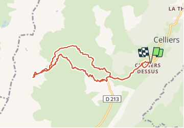

Length
10.3 km

Max alt
2387 m

Uphill gradient
1022 m
Km-Effort
24 km

Min alt
1358 m

Downhill gradient
1024 m
Boucle
Yes
Creation date :
2022-03-08 08:17:56.192
Updated on :
2022-03-08 14:55:16.988
4h46
Difficulty : Very easy

FREE GPS app for hiking
 SityTrail
IGN / Geographical institutes
SityTrail Plus
The world is yours!
About
Trail Touring skiing of 10.3 km to be discovered at Auvergne-Rhône-Alpes, Savoy, La Léchère. This trail is proposed by franquen.
Positioning
Country:
France
Region :
Auvergne-Rhône-Alpes
Department/Province :
Savoy
Municipality :
La Léchère
Location:
Celliers
Start:(Dec)
Start:(UTM)
297955 ; 5038782 (32T) N.
Comments